-
Notifications
You must be signed in to change notification settings - Fork 6
IncrementalModel_step3
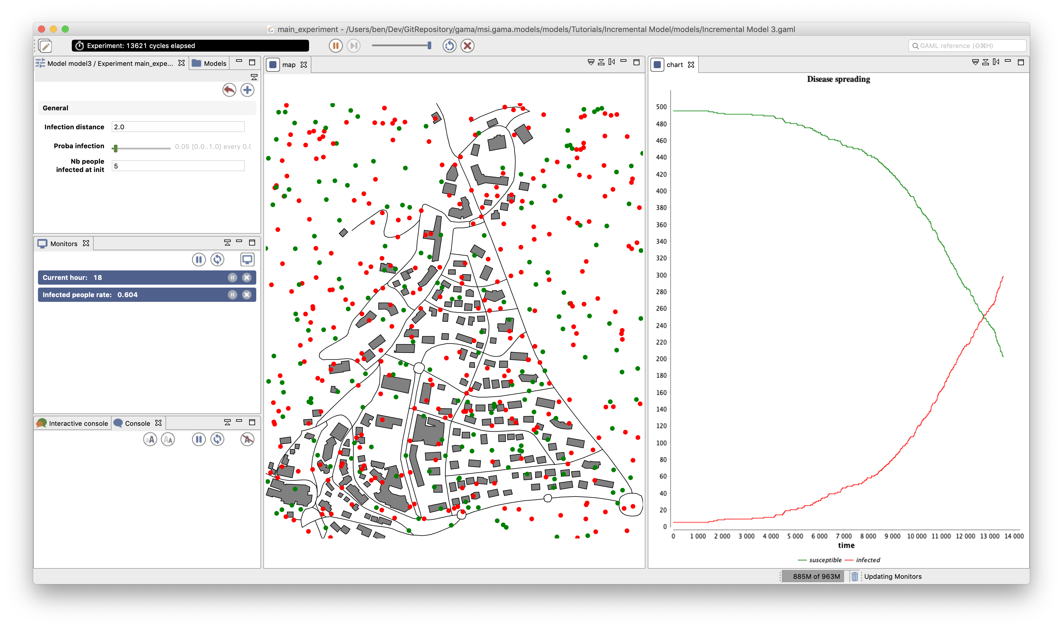
This step illustrates how to load and agentry GIS data.
- Load, agentify and display two layers of GIS data (building and road).
- Modify the initialization of the people agents to put them inside buildings.

To integrate easily the two data layers, we have to define two species of agents: the building agents and the road ones. These agents will not have a particular behavior, they will just be displayed.
We define an aspect for these species. In this model, we want to represent the geometry of the agent, we then use their geometry in the draw statement. In order to draw the geometry of the agent, we use the attribute shape (which is a built-in attribute of all agents).
species building {
    aspect default {
	draw shape color: #gray border: #black;
    }
}

species road {
    aspect default {
	draw shape color: #black;
    }
}
GAMA allows to automatically read GIS data that are formatted as shapefiles. In order to let the user chooses his/her shapefiles, we define two global variables. One allowing the user to choose the road shapefile, one allowing him/her to choose the building shapefile.
Definition of the two global variables of type file representing the GIS files:
global {
    file buildings_shapefile <- file("../includes/building.shp");
    file roads_shapefile <- file("../includes/road.shp");
}
In GAMA, the agentification of GIS data is very straightforward: it only requires to use the create command with the from facet with the shapefile. Each object of the shapefile will be directly used to instantiate one agent of the specified species.
We modify the init section of the global block in order to create road and building agents from the shapefiles. Then, we define the initial location of people as a point inside one of the buildings.
global {
    ...
    init {
	create road from: roads_shapefile;
	create building from: buildings_shapefile;
	create people number:nb_people {
	    speed <- agent_speed;
	    location <- any_location_in(one_of(building));
	}
	ask nb_infected_init among people {
	    is_infected <- true;
	}
    }
}
Note that the name of a species can be used to obtain all the agents of a species (here building returns the list of all the buildings). We can thus use the one_of operator on building to pick a random building agent. The any_location_in operator returns a random point inside a geometry or an agent geometry.
Building a GIS environment in GAMA requires nothing special, just to define the bounds of the environment, i.e. the geometry of the world agent. It is possible to use a shapefile to automatically define it by computing its envelope. In this model, we use the road shapefile to define it.
global {
    ...
    geometry shape <- envelope(roads_shapefile);
    ...
}
We add to the map display the road and building agents. Again, as we named the aspects default we can omit to specify them in the species inside the display.
In the experiment block:
output {
    display map {
        species road;
	species building;
	species people;
    }
    ...
}
https://github.com/gama-platform/gama.old/blob/GAMA_1.9.2/msi.gama.models/models/Tutorials/Incremental%20Model/models/Incremental%20Model%203.gaml
- Installation and Launching
- Workspace, Projects and Models
- Editing Models
- Running Experiments
- Running Headless
- Preferences
- Troubleshooting
- Introduction
- Manipulate basic Species
- Global Species
- Defining Advanced Species
- Defining GUI Experiment
- Exploring Models
- Optimizing Models
- Multi-Paradigm Modeling
- Manipulate OSM Data
- Cleaning OSM Data
- Diffusion
- Using Database
- Using FIPA ACL
- Using BDI with BEN
- Using Driving Skill
- Manipulate dates
- Manipulate lights
- Using comodel
- Save and restore Simulations
- Using network
- Headless mode
- Using Headless
- Writing Unit Tests
- Ensure model's reproducibility
- Going further with extensions
- Built-in Species
- Built-in Skills
- Built-in Architecture
- Statements
- Data Type
- File Type
- Expressions
- Exhaustive list of GAMA Keywords
- Installing the GIT version
- Developing Extensions
- Introduction to GAMA Java API
- Using GAMA flags
- Creating a release of GAMA
- Documentation generation